This page presents details of the housing and built environment in the East Farndon Parish, both in terms of historical activity and the most recent news in relation to potential major housing development impacting the village. It also details the contributions from East Farndon Parish Council (EFPC) to the latest West Northamptonshire Council (WNC) Local Plan.
Overview and History
Over the 20th century there was a considerable change in the appearance of the village. In medieval times, the majority of houses would have been thatched, with cob or mud walls. Gradually as the use of brick increased in the 18th century, more houses of some status were built, which probably reflects the increasing prosperity among some sections of the population. Some of these larger houses were still being roofed with thatch. Many of the humbler cottages survived through to the 20th century, but by the middle of the century they had all been demolished. The larger houses which had been thatched were re-roofed in tiles or slate. So today East Farndon has no thatched houses and is largely a brick-built village.
Population and Households
The latest population figures (2021) show East Farndon with 319 residents and 131 households (2024). Click here to read more detail on population and households.
Separation from Market Harborough
Historically the River Welland formed the border between Leicestershire and Northamptonshire. Thus the county border was previously further north from the village of East Farndon than it is at present. It is clear from past and recent surveys that there continues to be a strong and vociferous majority of residents of East Farndon who want the village to continue to be separate to Market Harborough. Click here to read more on separation.
WNC New Local Plan to 2043 – Summary at March 20th 2026
WNC are in the process of constructing a new Local Plan that will cover the period up to 2043. This new plan is currently subject to a Regulation 18 consultation, which means that organisations, councils and members of the public have the chance to have their say before the new plan is adopted. The consultation closes on March 27th 2026. Click this link to view the formal WNC documents and take part in the consultation process. EFPC will be considering the latest plan at their March 2026 meeting and if you have any comments, please use this link to email our Parish Clerk, Sarah Gresly.
EFPC have been monitoring progress and making inputs into this new plan, and are keeping a very keen eye on how housing development features for East Farndon. In addition, as we are on the border with Market Harborough, EFPC continues to monitor the development of the new Harborough Local Plan. EFPC submitted our drawn East Farndon Village Confines for the new WNC plan, but these are no longer required as the village has been re-classified as a small settlement / hamlet. EFPC made 4 nominations for local green spaces, Village Green, Marriott Green, Church Grounds, Church Burial Ground & Extension. These have all been accepted and are included in the new WNC Local Plan.
Note that the new local plan covers other matters in addition to housing, such as employment, infrastructure, climate, biodiversity, special landscape areas, heritage, flooding, transport etc. The provisions on heritage seem to be largely unchanged from the current provision.
East Farndon Village Confines, Local Green Spaces & Heritage
In the new WNC Local Plan, East Farndon has been classified, following a robust analysis of services and facilities, as a small settlement/ hamlet. This is the smallest settlement size of the four categories set by WNC. Drawn Village Confines are not required for a small settlement / hamlet and WNC regards the whole area as open countryside when considering housing and other development applications. New housing targets are not set for the small settlement / hamlet category. With this change, East Farndon seems to be well protected from new developments, but of course major strategic planning applications could be received, but these will be managed on a case by case basis. East Farndon is also in a special landscape area which offers further protection. As explained above, East Farndon has 4 Local Green Spaces in the new WNC local plan.
Click this link to view our drawn Village Confines, but note that these are not included in the latest WNC Local Plan as explained above: Village Confines Map
Click this link to see more details of our Local Green Space nominations. These are included in the latest WNC Local Plan as explained above: Local Green Space Nominations Map
In the previous WNC Local Plan consultation in 2024, WNC announced that parts of East Farndon are designated as a Special Landscape Area. This was determined by WNC, using their own criteria, versus being requested by EFPC. In responding to the 2024 consultation, EFPC did request that the area was extended up to the county boundary, but this was not accepted by WNC. Click this link to see the map from the 2024 consultation submission: 2024 Special Landscape Area Map
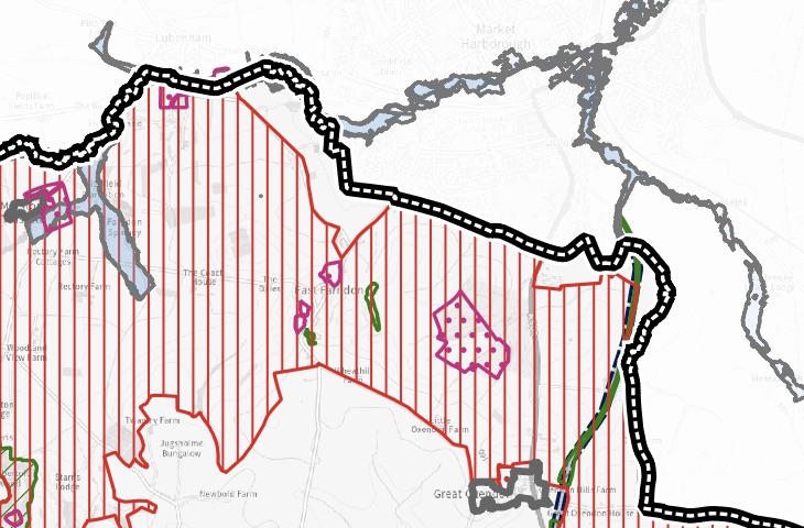
The latest WNC Local plan shows the WNC Special Landscape Area (red striped area on the map). Please click this link to view an extract that shows the impact on East Farndon: 2026 Special Landscape Area Map EFPC have resubmitted this request for the latest Regulation 18 consultation.
In addition, most people will know that East Farndon has medieval settlement remains in the village and this is a Historic England Scheduled Monument. This can be viewed in map form by clicking this link: Medieval Settlement Remains & Scheduled Monument Map
Major Housing Development – Summary at March 20th 2026
The parcels of land in the West Northamptonshire Council (WNC) spatial options strategy and call for sites documents, identified for potential major housing developments between East Farndon and Market Harborough, remain in the latest / new WNC Local Plan supporting documents. The good news is that all of these areas have been marked as not suitable and therefore will not be going ahead into the new housing areas to be developed for the latest Local Plan. It remains the case that Harborough District Council (HDC) could request these development areas from WNC, even though these areas are not identified in the latest HDC Local Plan. This is unlikely, but East Farndon Parish Council (EFPC) will continue to monitor closely the development of both the WNC and HDC Local Plans, as well as researching and responding quickly to any adhoc / speculative planning applications.
Archive Section
Major Housing Development – Previous Activity
EFPC met on 9th November 2021. A number of residents attended, and it was unanimously agreed that EFPC would object in the strongest possible manner to the proposals to build 2,000+ houses on land between East Farndon and Market Harborough.
Following the visit by our then local MP, Chris Heaton-Harris, on 14th Jan 2022, he confirmed his 100% support for the EFPC objections to these developments. He made his views known on his official social media and contacted Historic England on our behalf, who sent the following reply.
“Historic England has provided comments to West Northamptonshire Council’s (WNC) Spatial Options Consultation, which includes the proposed allocation at East Farndon. Our response expressed concern regarding the potential impact on the scheduled monument and advised that a detailed heritage assessment would be required at an early stage to ensure its significance is preserved, including contributions made by its setting. This would include areas of ridge and furrow that preserve the former medieval open field system and therefore make a positive contribution to the significance of the monument.
Note that the scheduled monument referred to by Historic England, relates to East Farndon medieval settlement remains. You can see the details by clicking this link, https://historicengland.org.uk/listing/the-list/list-entry/1017190?section=official-list-entry
The World War II crash site will be protected under the Protection of Military Remains Act 1986. It is an offence under section 2 of this act to tamper, damage, move, remove or unearth remains. Further information on this can be found at https://www.gov.uk/guidance/aviation-archaeology. The Parish Council can highlight their concerns regarding unlawful activity with the Joint Casualty and Compassionate Centre (JCCC) who licence lawful investigation of crash sites and will be able to advise further.”
Councillor Phil King, leader (at that time) of Harborough District Council (HDC), commented on the Facebook of Chris Heaton-Harris as follows, “I am not expecting that these sites, in adjoining West Northants will be required to deliver the anticipated housing needs for the Harborough district, as we review our adopted Harborough Local Plan”
Map of the Proposed Housing Development
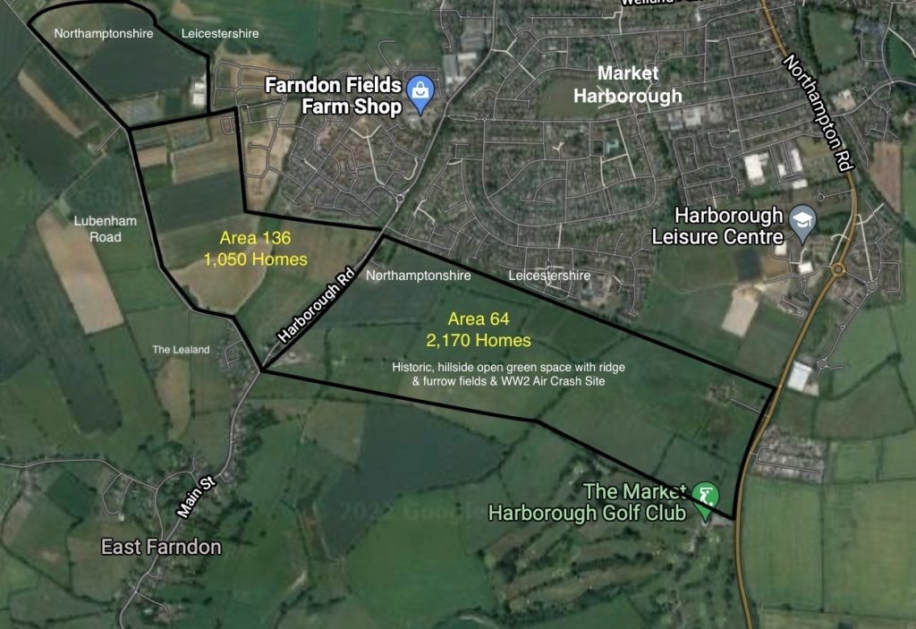
In early October 2021, WNC published a new Spatial Options Consultation document. This contained details of two potential major housing developments on land between East Farndon and Market Harborough. An extract from the WNC document, page 33, is repeated below, together with a map taken from Appendix 4, identifying the land areas being considered for development.
“An area of land situated to the South of Market Harborough has been promoted previously through the call for sites process with a potential capacity of approximately 2,000 dwellings. Whilst the site is well-related to Market Harborough and would enable access for sustainable travel modes it does feature some notable constraints, part of the area is identified as special landscape area and it is relatively close to nearby scheduled monuments. Further historic assets exist in East Farndon and any development would need to protect against coalescence.“
“Given the relationship of the area with Market Harborough, it is acknowledged that development in this location could help to meet the housing needs of Harborough District. As part of fulfilling requirements related to the duty to cooperate, discussions have taken place with officers at Harborough District Council and at present, given they are in the formative stages of updating their local plan it is not possible to establish at this time whether there is a need for land in this area to come forward. However, mindful that the WNSP covers the period to 2050 it felt appropriate to acknowledge the long-term development potential in this area and the need to maintain constructive dialogue with Harborough District Council moving forward.“
Ref 64 (see map above). Up to 2,170 homes on the right-hand side of the road between East Farndon to Market Harborough. This has been recommended to proceed to more detailed assessment with the site available before 2025.
Ref 136 (see maps above). Up to 1,050 homes on the left-hand side of the road between East Farndon to Market Harborough. Note that on the original document, this area was described as, “has not been recommended to proceed to more detailed assessment”. WNC have written to EFPC to say that this was an error, and that this area is also proceeding to a more detailed assessment.
You can read our Website Accessibility Statement via the link here: https://eastfarndon.org/parish-council-website-accessibility-statement/ If you require any information in an alternative format, please email the Parish Clerk at: clerk@eastfarndon-pc.gov.uk