
The Parish of East Farndon is very fortunate to have a wealth of rights-of-way, providing both locals and visitors a fantastic opportunity to explore the surrounding countryside.
Alan Langley, our resident Footpath Warden and historian, with support from Caroline Burton, our Parish Clerk, has put together a special collection of three walks around East Farndon to celebrate the Queen’s Platinum Jubilee.
This has been designed to be a printed leaflet that you can take with you as you enjoy the countryside around East Farndon. The full contents of the leaflet are shown on this page, however you can download a pdf copy to print or store on your pc or mobile device, by clicking the link below. Note that this pdf is designed for two sided printing.
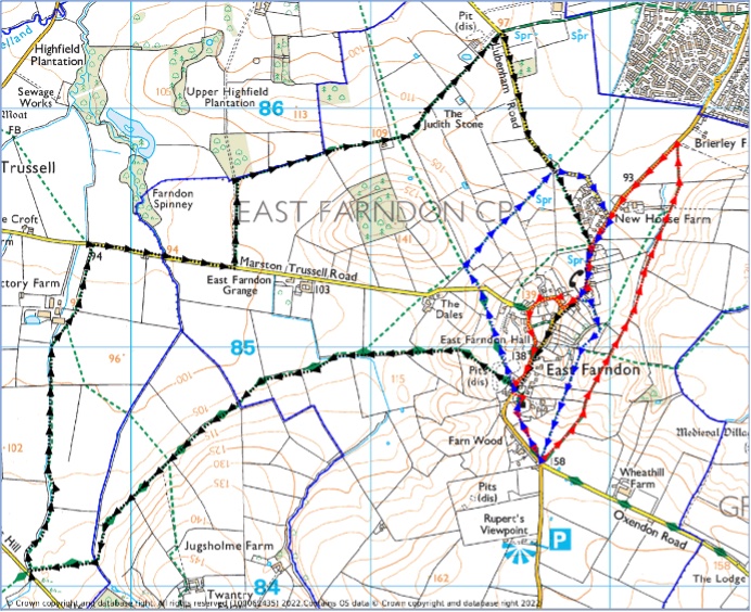
The walks leaflet is designed to help you explore the area, noting sites of interest, and provides three circular routes starting/finishing at the top of the village, by the beech tree on the triangular green near the church (there’s a bench to rest when you’ve finished!). As the walks are circular, you can join them at any point on the route that suits you. PLEASE keep to the footpaths and bridleways, which are public rights-of-way. On most gates and stiles, there are markers pointing the way. Walk One (marked in blue) and Walk Two (marked in red) are fairly short, while Walk Three (marked in black) is a longer route which goes into neighbouring parishes.
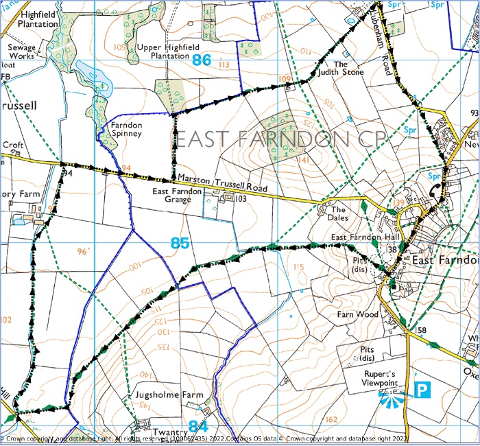
Walk One Map (Just under 2 miles)
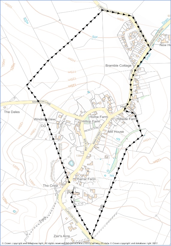
Walk One Description (Just under 2 miles)
From the triangular green cross the main road (carefully) and go up the drive of the house opposite, Redbrick Cottage. Keep over to the right and respect the privacy of the residents. Go through the wrought-iron gate on the right of the garage. Then continue to the stile which takes you into an open area, Hall Close.
Ahead you will see a signpost – make for that. Near the post you will be rewarded with a wide view westwards towards Marston Trussell and Sibbertoft. Also nearby are deep channels on either side, going roughly north-south. These are thought to be part of a hollow way, an old route used by villagers for many centuries. Behind you, in the lumpy ground between you and the road, are possible foundations of houses, where the village originally was situated. It may be that the area was cleared and the inhabitants made to move down the hill to make room for sheep farming, perhaps in the Tudor period.
At the signpost, follow the Jurassic Way sign to the right and walk towards a stile next to a gate at the edge of the field. You will come onto a surfaced drive for a few yards before going left over a stile with two steps into a sloping field. Bear right across the field to a stile and a second stile leading to the Farndon to Marston Road.
Look left down the hill and you will see a footpath signpost on the far side of the road, on a bend not many yards away. Turn off the road here, over the stile and down the sloping field. The hill ahead, with phone mast, used to have windmill on top until it was burnt down in a storm in 1897. Down in the dip cross the bridge and stile. A few yards further on, there is a stile in the hedge to your right. Go over this and the next one and carry on in this direction to another stile. Now you can see towards Market Harborough and Gartree Prison is visible over to the left. Crossing the next field, you reach another double stile. Now you may make out the road to Lubenham down below you. Descend the field to the bottom corner, by the metal gate. You go over the ups and downs of ridge and furrow, a legacy of the system of ploughing the open fields before they were enclosed in 1780-81. There is a stile in the corner. Cross over it to the road.
Turn right and walk along the road, past The Lealand cul-de-sac, to the main road to market Harborough. Turn right here up the hill of the village street. Keep on going up Main Street, past Ivy House, a former Baptist chapel and Bell House, a former pub. Just beyond here is the village hall. A footpath signpost shows you can turn left through the hall car park. Do this and walk round the narrow enclosed path behind the hall and down past the gardens of neighbouring houses. You descend to a footbridge and the emerge after a stile in a paddock. Turn right up the slope to a stile in the hedge ahead. This again is a double stile. In the more open field keep the hedge on your right and go straight ahead. A view gradually opens up behind you.
You will see houses over on your right as you reach a stile. Cross over and continue to another stile ahead. You will have to cross the next field in two directions. Go ahead diagonally to the right, up and across this field, with houses and gardens over to your right. Go to the metal gate in the far right-hand top corner, where there is a green footpath signpost. Do not go through the gate but turn round and walk parallel to the hedge on the left, towards the white house and church. Reaching a gate, go through into a field where you follow a raised bank on the right-hand side. You reach a second gate and go through into the churchyard. Follow the gravel path round the church and out of the churchyard and you will be back at your starting point a short distance to the left.
Walk Two Map (Just over 2 miles)
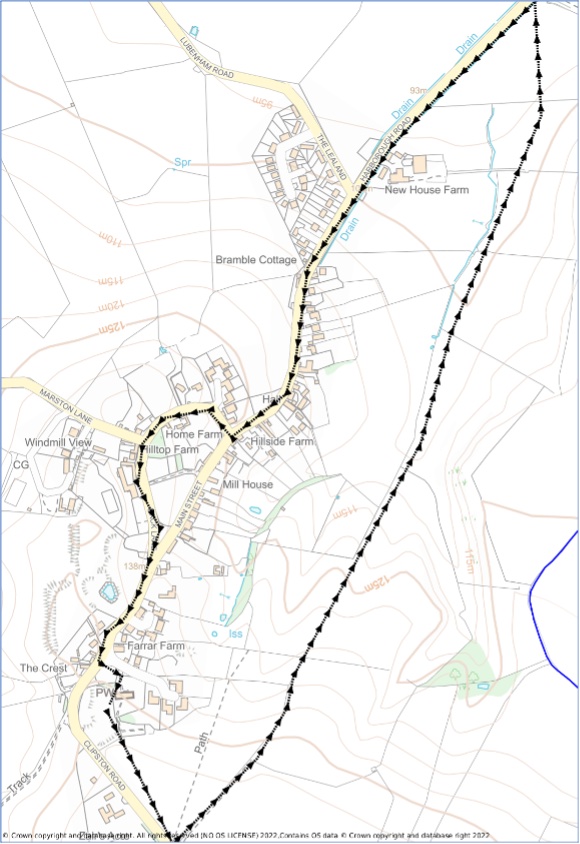
Walk Two Description (Just over 2 miles)
From the triangular green walk up to the church. Follow the gravel path round the church tower and ahead, just off to the right, is a kissing gate. Pass through this out of the churchyard and along a raised bank on the left-hand side of a lumpy field. Go through the gate at the end and carry on ahead with the hedge on your right. At the end of the field go through the gate on the right onto the road verge.
Turn left for a few paces and then go in through another gate next to a bridleway sign. Go along the track on the left-hand side of the field to another gate and pass through to a grassy field. A view opens up. Carry on in this field with the hedge on your left to a wide gap where the hedge ends. Go straight ahead with a deep valley on your left, making for a telegraph pole by a corner in the hedge ahead. Carry straight on past the pole and downhill with a hedge on your left. Keep on straight ahead through another gate. You are in a valley known locally as ‘The Gosse’, from the gorse bushes on the slope to your right.
Continue straight on through four more handgates. At each gate you will be able to see the next gate straight ahead. Some of the gateways may be muddy! Finally cross an open field diagonally to the left and reach the main road to Market Harborough. Turn left and follow the pavement along this straight stretch of road (the traffic can be very fast) until you enter the village once more. Continue up the steep village street, past the village hall until you see the War Memorial on the right, at the junction with Back Lane.
Turn right up Back Lane. Home Farm, on the corner opposite the Memorial is a listed building. Note the date 1658 on the barn next to the house. Carry on as the road bends left. On the left-hand side of the road, you will see ‘The Manor’, another listed building, bearing the date 1664. It was built for Thomas Lee, a Royalist supporter, after the monarchy was restored in 1660.
Crossing the turning to Marston you’ll see ahead, on the right-hand side of the road, East Farndon Hall, another listed building. The house was originally built in the late 17th or early 18th century and then much altered and enlarged. In 2020 it was completely remodelled back into a Georgian-style mansion, with the entrance once again in the centre, as it had been originally.
On reaching the main road again, go right, up the hill, and you will soon regain your starting point.
Walk Three Map (Just over 5 miles)
Walk Three Description (Just over 5 miles)
From the green, cross the road and go up the drive of Redbrick Cottage opposite. This is a public footpath but please respect the residents’ privacy. Go through the wrought-iron gate to the right of the garage and on to a stile. Crossing the stile, you come to an open grass field (Hall Close). Go ahead and slightly right to the three-fingered signpost. The deep grassy ditch you see to left and right was, it is thought, formerly a lane used by villagers to get to their strips in the village’s open fields. It also divided the village cottages from the fields on the sloping ground beyond. Follow the Jurassic Way sign straight on (not to the right). Descend with a fence on your right to a stile in the hedge. Another stile with a V-shape brings you to another steep sloping field with extensive views ahead. Cross a stile at the bottom of the field and then another stile across a small paddock. The next stile is now redundant as you can walk round it. Now go ahead along the edge of the field with the hedge on your left.
You may find the path is not as clear as it might be, but just keep the hedge on the left. Pass a big opening in the hedge and then, about 25 yards before the end of the field, go left through another gap in the hedge where bits of concrete show there may once have been a bridge over the ditch. Now keep going in the same direction but with the hedge on your right.
The path curves to the left and then continues straight on. When the hedge ends and goes away right at a right angle, you are faced by an arable field (there may be crops growing, depending on the time of year). You need to cross this field diagonally left to a stile over on the far side. There should be a visible path across the field for you to follow.
At the stile you will also find a footbridge across the ditch, which will take you up into the next field You are now in Clipston parish. You walk straight ahead along the right-hand edge of the field, with the hedge and a steep ditch on your right. The path may be narrow in this field, between the crop and the ditch. Go through the gate at the end of the field. The next field is grass and just keep ahead with the hedge on the right to the gate. Follow the hedge again in the next field of grass, ignoring the gate on the right and curving left to yet another gate.
Here you enter Marston Trussell parish. Pass to the left of a tree plantation and once again walk along the edge of the field, keeping the hedge on your left. The path may not be wide. As you approach the end of the field, you will see a gate leading to the Clipston to Sibbertoft road. Do not go through the gate, but turn right along another edge of the field you are in, with the hedge again on your left. Sometimes the path is hard to see, but just keep the hedge on your left. It curves to the right after a while.
Keep going ahead with the hedge on your left alongside three fields and you will be approaching the buildings of Rectory Farm. Go round the sheds onto the concrete area and then through the gap in the hedge ahead. Go a little way left to the edge of the field, with the hedge on your left, and then straight ahead to the East Farndon to Marston Trussell road. Turn right and walk along the road for about 400 yards. As you pass over a very small stream, you re-enter East Farndon parish.
When you see a bridleway signpost to Market Harborough on your left, go through the handgate and continue ahead along the right-hand side of the field, with the hedge on your right. At the end of the hedge, the path goes right and you will now have the hedge on your left. At the end of this field the path curves and you then will have the hedge back on your right. Go through the gate at the end into a field of grass and continue straight ahead.
You can make a small diversion here if you wish by going up a little way to your left. If you then look over to the hedge on the right, you will see the Judith Stone, probably so called because it was on the land held by the Countess Judith, niece of William the Conqueror, back in the 11th century. The stone is a glacial erratic, that is, it was brought here from somewhere else, possibly even south Scotland, by a glacier in the ice age. Return to the path.
Resuming, continue through the metal gate at the end of the field and follow the hedge on the left along the edge of the next three fields, past Farm Shop crops (depending on the time of year) and then straight on to the Farndon to Lubenham road. Turn right along the road.
Continue along the road for about 400 yards. Then, opposite the green seat, take the left of the two paths shown on the signpost on the right. Cross over the stile and go diagonally left and pass by the gardens of the houses till you come to a metal gate which leads onto Farndon’s main street. Turn right and continue uphill till you reach your starting-point at the top of the hill.
You can read our Website Accessibility Statement via the link here: https://eastfarndon.org/parish-council-website-accessibility-statement/ If you require any information in an alternative format, please email the Parish Clerk at: parishclerk.eastfarndon@gmail.com